Wednesday 20 May 2009

Beyond the LCC maps – further resources for investigating London’s war

Great though the LCC maps are, they only give us a snapshot of damaged property in 1945. They tell us nothing about when the bombs fell, how many there were, or what kind of bombs. They also tell us nothing about casualty numbers.

But these data were carefully collated throughout the war, and documents in the London Metropolitan Archives and National Archives help to extend our understanding of the period.

The London Metropolitan Archives hold the incident logs kept by local authorities, which detail the number and type of bombs received, and damage and casualties incurred. They were also plotted on bomb census maps, held by the National Archives:

Bomb census 21 10/40 sheet 56/18 NE
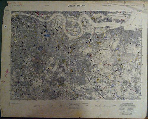
Bomb Census Map for South East London, October 1940.

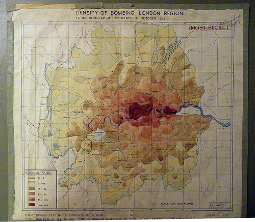
These data were used to estimate density of attacks over the entire London Civil Defence Region - a larger area than the LCC maps cover, roughly corresponding to the Metropolitan Police Area.

This map from the National Archives shows density of bombing in the London region from outbreak of hostilities to October 1941. This shows how heavily the whole of Central London, both north and south of the river was bombarded, alongside dock areas and Chelsea
Density of bombing London region from outbreak of hostilities to October 1941

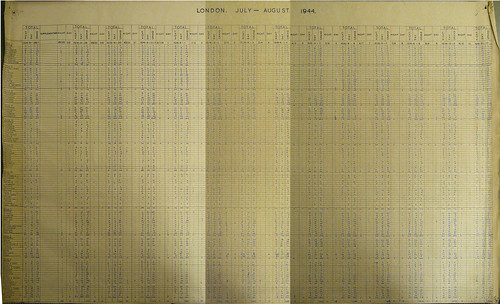
The National Archives also hold tables of incidents. This table shows incidents by area for 2 weeks during the height of the V1 attacks in summer 1944.
Casualties

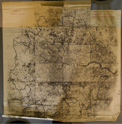
The London Civil Defence Region also produced maps of V-weapon strikes. These were widely scattered, but concentrated south of the river. What this map does not show is the number of bombs shot down or falling short of the target in Kent.

Map from the National Archives showing V1 attacks up to 7th August 1944.

fall of fly 15-6-44 to 7-8-44

All these documents are freely accessible to the public at London’s archive centres. Together with the LCC maps, they form a formidable resource for anyone interested in London’s wartime history, helping to provide the chronological framework and document the human cost of the bombing of London.

Wednesday 6 May 2009

My LCC maps on the web

Since I took photos of the LCC maps at the LMA, several people have blogged them or linked to them in local London community forums.

I hope to get on to some more interesting discussion relating to the maps, but firstly, I thought it would be useful to highlight some of these responses to the maps. If you know of any I've missed, I'd love to hear from you.


View V2 rockets on London in a larger map

Londonist - Matt Brown's blogpost and googlemap of V2 strikes (see above) based on my LCC maps set.
5 rocket sites I am near - Neat little application by Tom Taylor, based on Matt Brown's map.
nerviosismo - Related post in Spanish.
Airminded - Pick-up on Londonist's map.
Yorkshire Ranter - Pick-up on Airminded blog.
Transpontine - Post on New Cross Woolworths V2 strike, response to Londonist blog.
Brockley Central Local blog discussing bomb damgae, referring to maps.
SE23.com - Local forum discussion linking to several maps.
Camberwell Online - Local forum discussion linking to relevant maps.
Blackheath Bugle - Local blog on Blitz damage.
hughw36 - Pick-up on Blackheath Bugle blog.
Greenwich Phantom - Local discussion inspired by the Londonist blog... and more in the comment thread on this post about bomb damage at Maze Hill.
London at War - Flickr group discussion.
Pistonheads - Motor forum thread. Their posting rules do not allow me to contribute to the discussion.

Some of these are repetitive and refer back to each other, but I wanted to gather them in one place.

We have also had interesting discussions on the photos within flickr, but these are less formal. I hope to collate some of the gems from those threads in a future post.

[Edited to add references to this blog, 22/05/09]
florizel.canalblog.com - Unfortunately, I'm not sufficiently confident at French to reply.
www.wowblog.co.uk - Response to LCC bomb damage maps post.

Monday 4 May 2009

Introduction to the LCC Bomb Damage Maps

At the end of the Second World War, The London County Council commissioned maps detailing the nature and extent of bomb damage throughout the capital. These maps are kept at the London Metropolitan Archives, who also have a facsimile set on public view. In Autumn 2008, I photographed the full set, and made them available on flickr.

War torn London - the big picture
Composite image of LCC bomb damage maps

A book of these maps was produced by the London Topographical Society, but is very difficult to get hold of. Some London Borough Libraries have copies for reference, but I feel these maps should be more widely available.

The maps highlight damage to each individual dwelling – coded from black (total destruction) to yellow (minor damage). Documentation of damage to public buildings is somewhat erratic. Here is a sample map of an area of Kennington in South London which suffered considerable damage:

Key:
Black
- Total destruction
Purple - Damage beyond repair
Dark Red - Seriously damaged, doubtful if repairable
Light Red - Seriously damaged, repairable at cost
Orange - General blast damage, minor in nature
Yellow - Blast damage, minor in nature
Green - Clearance areas
Small circle - V2 Bomb
Large circle - V1 bomb


These maps are fascinating documents, and extremely useful for investigating London’s wartime history, but they do have shortcomings. The most frustrating of these is that they only cover the LCC area, which excludes badly hit areas of Essex, Kent, Surrey and Middlesex which were already very built up, and now form part of Greater London.

LCC Boundary Map, 1948
The LCC covers the red area here - as you can see, much of Greater London is excluded.

The local authorities in these areas produced their own maps, which are less well documented than the LCC maps (see an example of a map for Wimbledon here). The Middlesex County Council Maps are held by the LMA, and resemble the LCC maps, but have a different, less detailed, colour scheme.

Neasden bomb damage map
Middlesex County Council Bomb Damage Map for Neasden

My flickr set of these maps provoked lively discussion and numerous responses on blogs and local community forums. My next post will highlight some of these. Future posts will examine some of this material further, in combination with modern mapping and information technology.

Sunday 3 May 2009

Scope and aims of this blog

In 1940, London found itself at the frontline of the Second World War. By 1945, a third of its housing stock was destroyed, and over a million people were homeless. Central and local government kept records of this devastation, many of which can be found in the National Archives and London Metropolitan Archives.

In 1945, The London County Council commissioned maps detailing the nature and extent of bomb damage throughout the capital. Future posts will examine some of this material, and how it can be combined with modern mapping and information technology to improve our understanding of London’s wartime experience, and the lasting effects on our city.

Life in the capital continued throughout the war, and important work was undertaken to support the war effort. Deep below Smithfield Market, future Nobel laureate, Max Perutz, was working on the top-secret Project Habbakuk (sic). In future posts, I hope to recreate some of the experiments, and explain some of the science and history behind them.

Meanwhile, whilst most of London’s colleges and universities evacuated to places of relative safety, Birkbeck College kept functioning throughout the war, right in the heart of London. In the 50’s, classics professor, E. H. Warmington, recalled Birkbeck’s wartime experience. I will use excerpts of his work to retell Birkbeck’s wartime story for a modern audience.

I have been meaning to write about this for a while, so when I had to create a blog for an assignment for Birkbeck’s News on the Net course, it seemed the ideal opportunity.

Friday 1 May 2009

Habakkuk

star

Behold ye among the heathen, and regard, and wonder marvellously: for I will work a work in your days which ye will not believe, though it be told you.

Habakkuk 1:5, AV.

Or to put it another way: I have several kilos of papier mâché in my freezer.

Watch this space...